Since my visits in 2014, the residents have been working on clearing the lake’s vegetation and have succeeded as covered by the Chinook Observer August 2019.
There are five posts here, one above the other, newest first. This is meant to keep together all the posts regarding Loomis Lake for easier reference later. This system made more sense to me than a scattered chronological order of all trips.
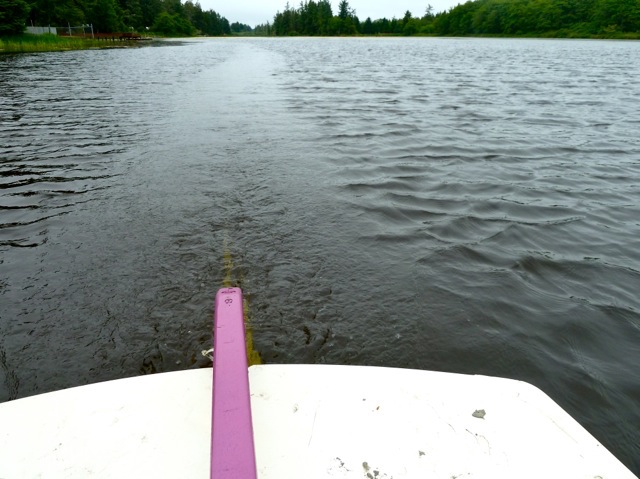
August 7, 2022, I launched the Hobie kayak from Tides West and paddled to the north end lily patch and back.
January 6, 2020, I launched the Hobie sailboat from the the end of 198th and paddled a quarter mile down the northern outlet.
November 26, 2014, I sailed/paddled the Hobie north to 198th and south to an abandoned dock.
September 27, 2014, I launched the Hobie sailboat from a reedy dock at Tides West for a short sail and paddle.
June 7, 2014, I launched the Force 5 sailboat from the public launch and reached the northern end.
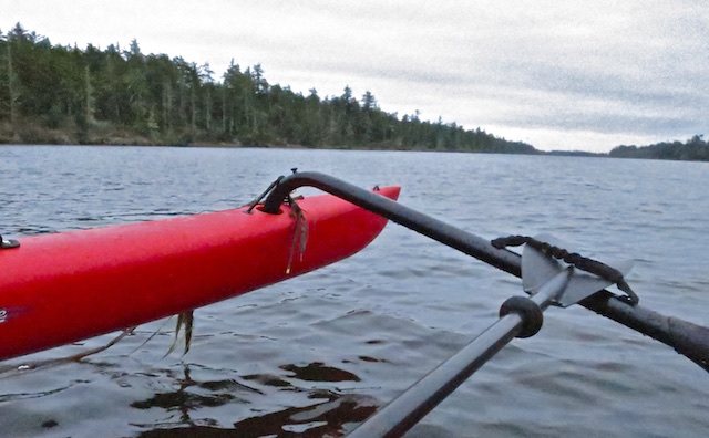
7 August 2022: Loomis Lake
Yesterday we had a garden get together in our back yard celebrating the blooming of our lilies (and more).

There, among the flowers, I listened to Janet who was looking forward to her very first kayak trip the next day. It would be on the local Loomis Lake guided by one of the people helping to keep a handle on its invasive aquatic plants.
Until I had my boat skills sorted out, and many mistakes made, I would always seek company to paddle with as they would help turn me right side up if things got tippy. At a minimum I would plan paddle trips within in sight of people fishing and/or tourists.
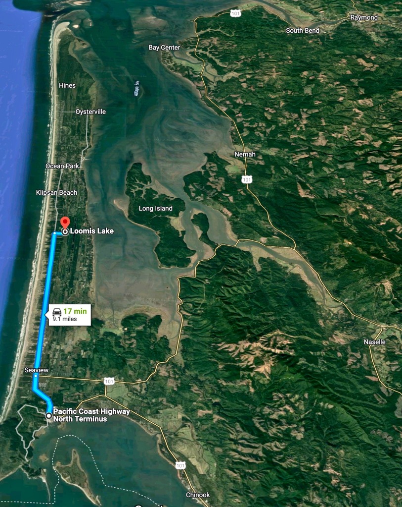
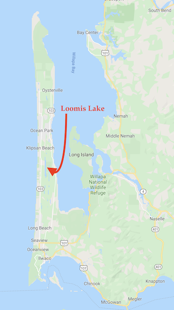
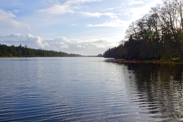
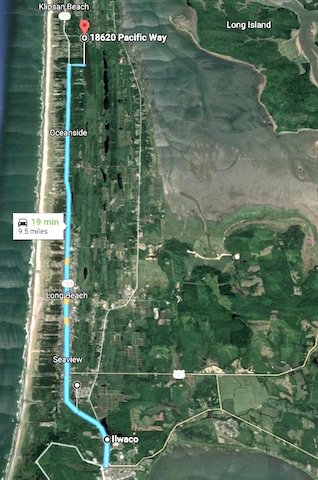
I had already made plans for tomorrow to launch onto the North Nemah River and maybe later onto the lower Naselle River. I checked them both out but didn’t launch at either. That story will be written later. Sometimes it’s better putting the boat back on the car and moving on, like to Loomis Lake. Maybe I could join Janet and her friend. It wouldn’t be crowded. The lake is 1.8 miles long, the largest lake on the Long Beach Peninsula. From Ilwaco, the Northern Terminus of the Pacific Coast Highway according to Google, it’s just an additional nine miles.
The public launch on 188th would be open but Janet and her friend were launching from the private Tides West dock. I am not a resident, but have been a guest of several residents before. I could name drop, be polite, or even try a bribe if needed.
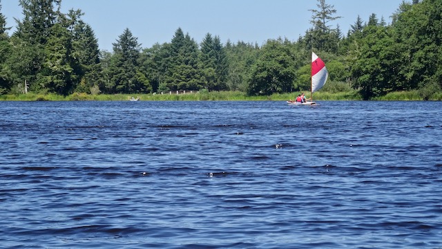
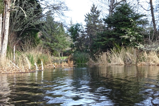
With my little waterproof monocular I thought I spotted two kayakers at the north end beyond a sail boat so I hurried to unload and launch.

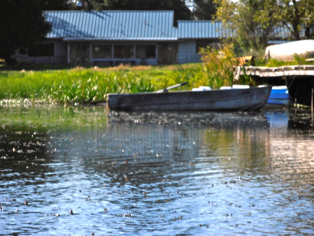
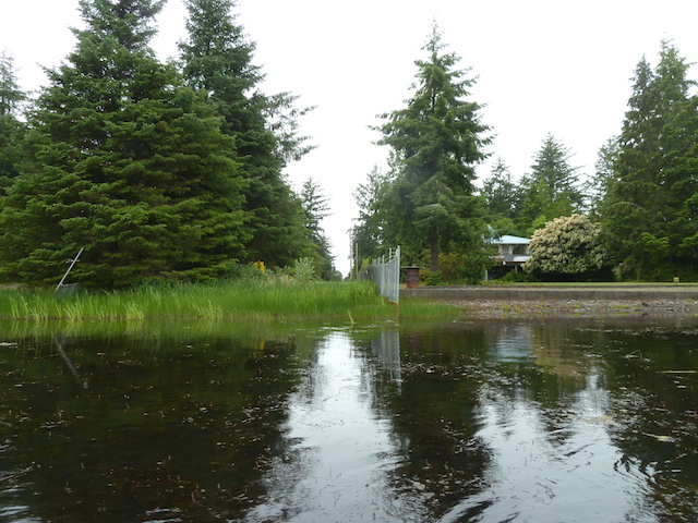
The public launch is actually is easier to get into the water. This picture is from a fun day out on the lake September 2014 with my boat from the Black Lake Yacht Club.

This dock is high for me but wading in works and is stable.

The sailboat turned out to be an El Toro. It’s small, fun, affordable, and very popular for racing as it is easy to gather a group of identical boats where skill wins the race.
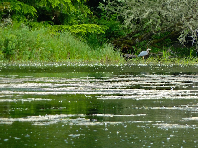
When I reached the north end, the kayakers were not to be seen. I did spot a nervous mother duck at a distance with her two little ones near the shore. They soon disappeared under the growth.

I was watching them using telephoto. This fellow overhead was watching too.


Soon a heron flew away. Maybe there was too much activity interfering with its quiet fishing time.

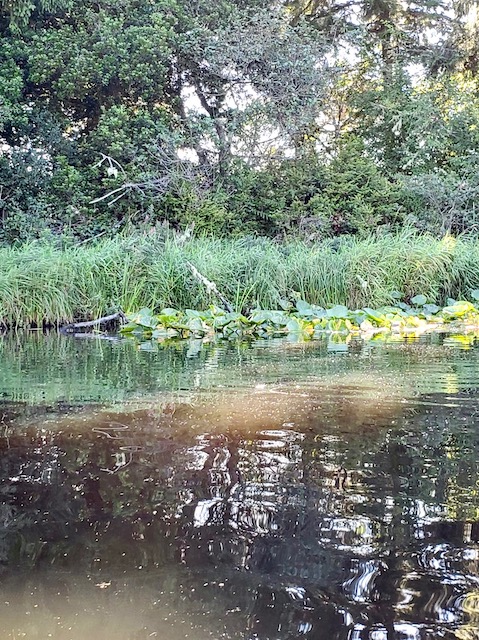
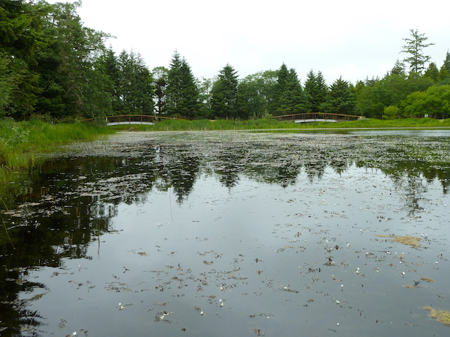
The north end was lined with water lilies preventing further access northward. I once found the way clear in January when the water was high and the vegetation had died back for the winter.
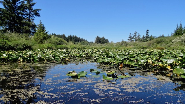
Today the flowers were out.
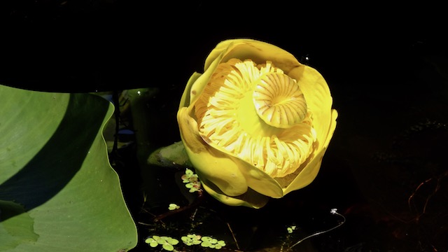


I could hear the ocean that was less than a mile away as I tried to film the blue dragon flies among the water lilies.
I spent a good while in the lilies trying to get good pictures and watching the red-wing Blackbirds, the blue dragon flies and other water bugs..
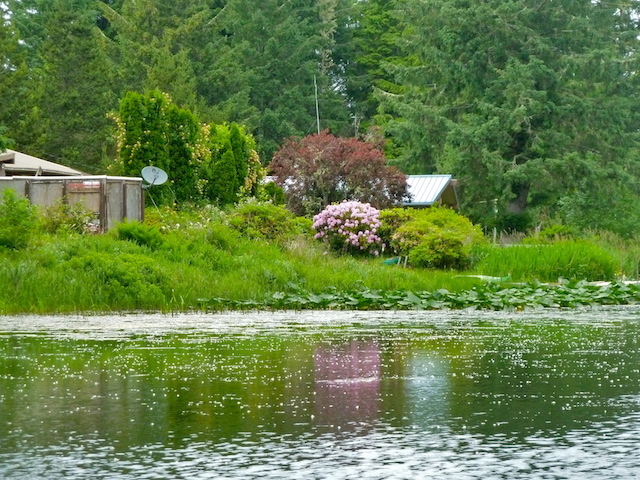
On the way back a few residents were out. One was busy on his dock, another one was mowing while his two kayaks awaited.

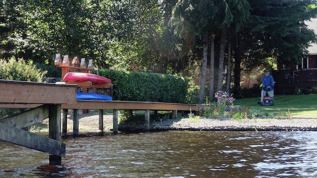
There was a gathering of paddle boats.

I spotted the sailboat from earlier today up on its dock. The yard nearby was flying a Finnish flag high on their flag pole as we have a large local Finnish population. It used to be said that you had to be of Finnish background or from a family who has been here for 100 years to truly be considered a local Ilwacoan.


It was time to bring my boat to back to dock too.

Turns out that Janet had had a great time too. Here are a couple of her pictures.

Inspired by a gathering in a lily garden, I had spent about an hour paddling and time among the lake’s lilies.

6 January 2020: North out of Loomis Lake
Today started out blustery, bracing and wet. It was raining and cold last week and so it will be next week.
Still, I have recently began following the NW Kayaking Facebook page where almost daily someone posts what a lovely time they’re having out on a paddle, albeit bundled up and sometimes with rain circles in the water.
With an afternoon predicted to be cloudy but windy, I bundled up, packed the sail kit and took the kayak to nearby Loomis Lake.
WDFW will unlock their ramp and fishing will begin the last day of April.
Today I used an undeveloped right-of-way I found and have listed in my book of SW Washington launch sites.


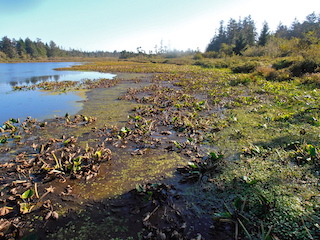
The local newspaper reported in April 2019 that there has been… “significant success….in cleaning up the weed-infested Loomis Lake.” The last time I boated here was a summer six years ago and it was slow going.
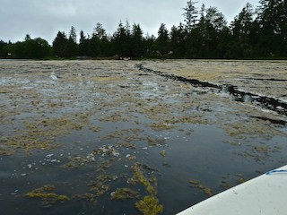
Today the water was clear, though like our gardens, the plants are sleeping for the winter. I only had to paddle through a bit of debris.

Across the lake I spotted another kayaker quickly heading south. Knowing my comparative lack of speed, I headed north.
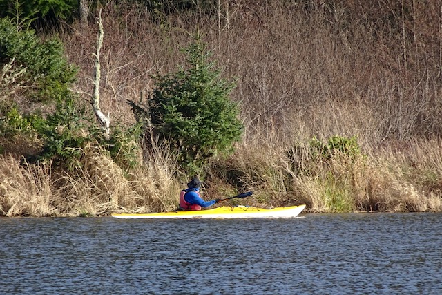
Paddling three times his boat’s weight and with no help from the wind, I was outclassed today. Maybe we’d meet later.
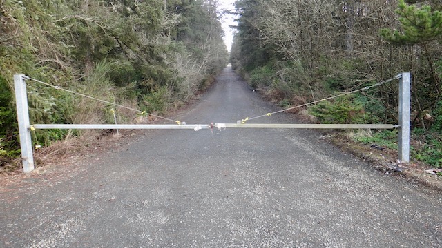
There’s a small bay across the lake that’s mostly surrounded by a community center. I’ve driven to its entrance but it’s gated and locked.

I’ve shied off entering the bay in the past but invaded it today disguised as attractive ambience to anyone watching. There was only one parked car.
Many rivers are currently flooding and on this afternoon the tide was low but lakes are actually improved by rain. The shore is more accessible and the hazards are covered.
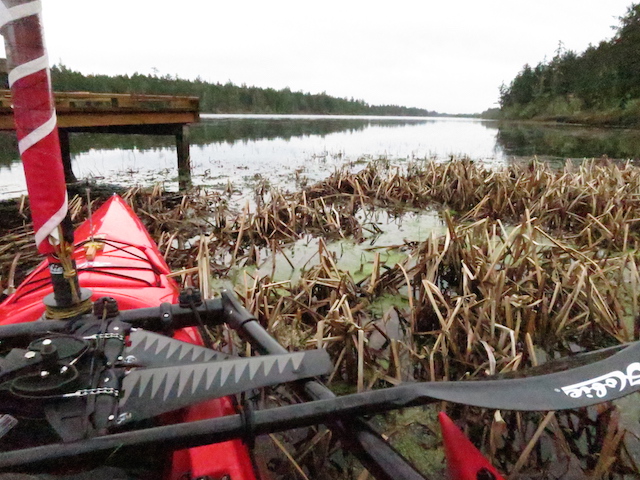
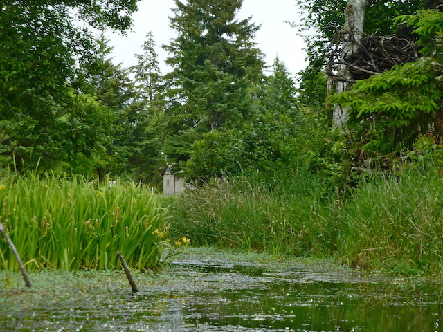
Dawdling back and forth across the lake, I was enjoying the experience without wanting to make it a workout. Then I spotted the other kayaker paddling back from the south. So, while I looked slightly busy as etiquette required, he came over and we traded greetings. Turned out he lives on the lake and paddles often, like others might go out for a walk. We talked about the Ilwaco’s Baker Bay Race from over 15 years ago in which we both had stayed near the back but still won an award in our class. We also compared notes on local kayak spots and a someday plan to visit one together. Then he tipped me off about a beaver dam a ways downstream off the northern outlet of the lake.

Up to the north end I paddled to check it out. I hadn’t seen this outlet before but to be fair, I never looked when the lake had had so much water.


I feel small streams are best done with little inexpensive boats. I was thumping into the brush, backing off tree branches, but having thorough fun while exploring where few have gone before. I remember thinking how this boat handled like a pig but that was unfair.


Invasive plants are still here.


The waterway still stretched out ahead. If it hadn’t been getting late, if the boat were lighter and, if I were a proper explorer like I read about in my books, I might have kept going.

It was back south to the launch.


26 November 2014: Sailing to South Loomis Lake
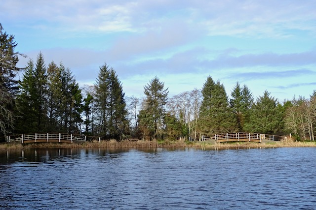
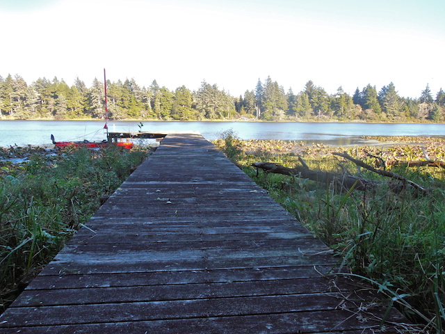
The state park access was closed for the season. Fortunately, having a friend residing in Tides West just a block from a little lakeside park made it possible for me to launch from there as a guest.

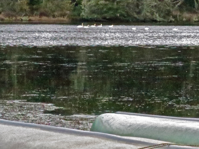
I felt it was a better day for the birds and the bird-watching residents before I intruded. There were over a dozen swans when I first arrived. I quietly walked to the water’s edge with my camera but they had moved to the other side of the lake and were gone before I dragged the boat through the shoreside weeds.


The Tides West community plans to continue to clean up this lake, as evidenced by meetings listed on their website. (They have succeeded as per this article from an August 2019 issue of The Chinook Observer.)

In typical staycation fashion, I did not get out of the house until mid-afternoon, so it was a short boating excursion. Afterward, I stopped by my friend’s house to help her put up her storm windows.

27 September 2014: Sailing to South Loomis Lake
Last time I was here was June 9 the wind blew from the north. I rowed up to the northern tip & sailed back. Today I sailed and paddled the red Hobie AI north upwind to 198th where a friend of ours used to live.
The lake was very shallow with plant growth so I drifted south a mile to watch the birds and look at the houses. I saw several noisy herons, mallards, gulls and jumping fish.


I rolled up the sail and started paddling upwind but found sailing easier & quick enough. Dinner reservations were three hours away.


Here are some pictures of other people’s boats.


7 June 2014: Sailing to North Loomis Lake
Saturday, 7 June 2014 (mostly written by Skyler)
By the time I got back from brunch with Kathleen and the Saturday Market, Allan had gone boating. I cleverly deduced this because his little sailboat was gone. He told me later that Black Lake was crowded with fishing folk so he went on up to Loomis Lake instead.
“Loomis Lake opens the last Saturday in April through October 31st. This shallow and weedy lake provides fair fishing for largemouth bass and yellow perch. It receives rainbow trout plants prior to opening day. The WDFW access provides a gravel boat launch and an ADA accessible vault toilet. The launch site is shallow and difficult for trailered boats. A boat/fishing dock constructed with RCO funds was badly damaged by storms in 2005 and again in 2006 and has since been removed. Lake Acreage: 149.9 Elevation: 20 feet” from: https://wdfw.wa.gov/fishing/washington/535/& Wildlife.


I had to tack back and forth through the vegetation in order to head north. A paddling route would follow the clearer channel up the middle.


I stayed outside the entrance as I thought it might be someone’s estate. It turns out to be the private and gated Sunset Sands Community Association park. Probably it is not so off limits next time from the water if the park is empty and I stay in the boat.


It would not be easy to launch here as there is no beach.
I could hear the ocean that was less than a mile away as I tried to film the blue dragon flies among the water lilies.
I spent a good while in the lilies trying to get good pictures and watching the red-wing Blackbirds, the blue dragon flies and other water bugs..
On the way back a few residents were out. One was busy on his dock, another one was mowing while his two kayaks awaited.
There was a gathering of paddle boats.
I spotted the sailboat from earlier today up on its dock. The yard nearby was flying a Finnish flag high on their flag pole as we have a large local Finnish population. It used to be said that you had to be of Finnish background or from a family who has been here for 100 years to truly be considered a local Ilwacoan.
It was time to bring my boat to back to dock too.
Turns out that Janet had had a great time too. Here are a couple of her pictures.
Inspired by a gathering in a lily garden, I had spent about an hour paddling and time among the lake’s lilies.
6 January 2020: North out of Loomis Lake
Today started out blustery, bracing and wet. It was raining and cold last week and so it will be next week.
Still, I have recently began following the NW Kayaking Facebook page where almost daily someone posts what a lovely time they’re having out on a paddle, albeit bundled up and sometimes with rain circles in the water.
With an afternoon predicted to be cloudy but windy, I bundled up, packed the sail kit and took the kayak to nearby Loomis Lake.
WDFW will unlock their ramp and fishing will begin the last day of April.
Today I used an undeveloped right-of-way I found and have listed in my book of SW Washington launch sites.
The local newspaper reported in April 2019 that there has been… “significant success….in cleaning up the weed-infested Loomis Lake.” The last time I boated here was a summer six years ago and it was slow going.
Today the water was clear, though like our gardens, the plants are sleeping for the winter. I only had to paddle through a bit of debris.
Across the lake I spotted another kayaker quickly heading south. Knowing my comparative lack of speed, I headed north.
Paddling three times his boat’s weight and with no help from the wind, I was outclassed today. Maybe we’d meet later.
There’s a small bay across the lake that’s mostly surrounded by a community center. I’ve driven to its entrance but it’s gated and locked.
I’ve shied off entering the bay in the past but invaded it today disguised as attractive ambience to anyone watching. There was only one parked car.
Many rivers are currently flooding and on this afternoon the tide was low but lakes are actually improved by rain. The shore is more accessible and the hazards are covered.
Dawdling back and forth across the lake, I was enjoying the experience without wanting to make it a workout. Then I spotted the other kayaker paddling back from the south. So, while I looked slightly busy as etiquette required, he came over and we traded greetings. Turned out he lives on the lake and paddles often, like others might go out for a walk. We talked about the Ilwaco’s Baker Bay Race from over 15 years ago in which we both had stayed near the back but still won an award in our class. We also compared notes on local kayak spots and a someday plan to visit one together. Then he tipped me off about a beaver dam a ways downstream off the northern outlet of the lake.
Up to the north end I paddled to check it out. I hadn’t seen this outlet before but to be fair, I never looked when the lake had had so much water.
I feel small streams are best done with little inexpensive boats. I was thumping into the brush, backing off tree branches, but having thorough fun while exploring where few have gone before. I remember thinking how this boat handled like a pig but that was unfair.
Invasive plants are still here.
The waterway still stretched out ahead. If it hadn’t been getting late, if the boat were lighter and, if I were a proper explorer like I read about in my books, I might have kept going.
It was back south to the launch.
26 November 2014: Sailing to South Loomis Lake
The state park access was closed for the season. Fortunately, having a friend residing in Tides West just a block from a little lakeside park made it possible for me to launch from there as a guest.
I felt it was a better day for the birds and the bird-watching residents before I intruded. There were over a dozen swans when I first arrived. I quietly walked to the water’s edge with my camera but they had moved to the other side of the lake and were gone before I dragged the boat through the shoreside weeds.
The Tides West community plans to continue to clean up this lake, as evidenced by meetings listed on their website. (They have succeeded as per this article from an August 2019 issue of The Chinook Observer.)
In typical staycation fashion, I did not get out of the house until mid-afternoon, so it was a short boating excursion. Afterward, I stopped by my friend’s house to help her put up her storm windows.
27 September 2014: Sailing to South Loomis Lake
Last time I was here was June 9 the wind blew from the north. I rowed up to the northern tip & sailed back. Today I sailed and paddled the red Hobie AI north upwind to 198th where a friend of ours used to live.
The lake was very shallow with plant growth so I drifted south a mile to watch the birds and look at the houses. I saw several noisy herons, mallards, gulls and jumping fish.
I rolled up the sail and started paddling upwind but found sailing easier & quick enough. Dinner reservations were three hours away.
Here are some pictures of other people’s boats.
7 June 2014: Sailing to North Loomis Lake
Saturday, 7 June 2014 (mostly written by Skyler)
By the time I got back from brunch with Kathleen and the Saturday Market, Allan had gone boating. I cleverly deduced this because his little sailboat was gone. He told me later that Black Lake was crowded with fishing folk so he went on up to Loomis Lake instead.
“Loomis Lake opens the last Saturday in April through October 31st. This shallow and weedy lake provides fair fishing for largemouth bass and yellow perch. It receives rainbow trout plants prior to opening day. The WDFW access provides a gravel boat launch and an ADA accessible vault toilet. The launch site is shallow and difficult for trailered boats. A boat/fishing dock constructed with RCO funds was badly damaged by storms in 2005 and again in 2006 and has since been removed. Lake Acreage: 149.9 Elevation: 20 feet” from: https://wdfw.wa.gov/fishing/washington/535/& Wildlife.
I had to tack back and forth through the vegetation in order to head north. A paddling route would follow the clearer channel up the middle.
I stayed outside the entrance as I thought it might be someone’s estate. It turns out to be the private and gated Sunset Sands Community Association park. Probably it is not so off limits next time from the water if the park is empty and I stay in the boat.
It would not be easy to launch here as there is no beach.

I am the owner of the mystery dock on the southwest shore above, there is no house, it is conservation property now managed by the nature conservancy with hope of returning the silverspot butterfly to its habitat. I am glad you enjoyed your paddle. the lack is much more weed free at this time.
LikeLike
Thank you for information Nicole. I have just now dropped the emphasizing the weeds in the blog’s intro and included this link to the summer’s positive Chinook Observer’s review. https://www.chinookobserver.com/news/local/loomis-lake-protectors-delighted-with-progress/article_04ee0ce0-5fad-11e9-9e5d-0f27866bc9a7.html. I really need to revisit the lake and thank you for all you and others have done to restore the lake. Looks like I caught it in a bad era.
LikeLike