Off to Paddle the Willapa Bay

Decisions, Decisions… a blogging tour

Here is a list I put together to help explore the Willapa Bay and its tributaries. It’s not the only one but reflects my abilities and preference to keep close to a shoreline. The Washington Water Trails Association also posts their list of thirteen Willapa Bay Water Trail Access Points here. Importantly, they offer a page of frequently asked questions about the Willapa Bay here. My modest expertise ends at the launch site where I have been known to drop my boat off the van (once). I don’t work for any of the many groups that study and preserve this area. I hope you get ideas for your adventures ahead on Willapa Bay and enjoy my posts of this region. This was updated July 2023 as South Bend repaired their city kayak dock to as it was before their big dock sank and Raymond replaced their kayak platform with a pull-by-paddle kayak dock identical to the one in Wheeler Oregon.

Working clockwise from Willapa Bay’s entrance to the Pacific Ocean, I am starting at this intersection located at the north end of Raymond. Turning west towards Grayland and Westport will take us to the most northern launch points onto the Willapa Bay on SR 105.

#1 Tokeland Marina From the intersection of US 101 and SR 105 in Raymond, drive 22 miles west. If you choose to launch from the marina you’ll find yourself on open water near the Pacific Ocean requiring a careful appraisal of the tide, weather, and your skills. Below is the ramp and a view towards the Willapa River.

The nearby Cedar River flows through a weir and tide gate into the Willapa Bay. Its entrance is a 7 mile round trip paddle from the Tokeland Marina. It requires a portage up a steep riprap beach and across SR 105. I enjoyed a 3.6 mile round trip paddle up to its shallows by driving to its mouth as written about in this post. Shown is the Cedar River’s gate to the bay and a view upstream.

#2 Smith Creek From the intersection of US 101 and State Route 105 in Raymond, drive west 10 miles and launch by the Smith Creek bridge. An undeveloped quiet 9 mile round trip written about here. Staying close to shore, with cautious planning for the weather and tide, it’s a 7 mile one way trip to the Tokeland Marina, South Bend or the beach below the Bruceport Campground.

#2 Smith Creek The access to North River is a 500 foot paddle from the adjacent Smith Creek. I paddled a quiet 13.2 mile round trip past floating cabins and the occasional recreational fishing boat as posted here.

#3 Wilson Creek. At the intersection of US 101 Hwy. and SR 105 at Raymond, drive east on Monohon Landing Road 4 miles up the Willapa River. From here you can paddle up or downstream towards the Willapa Bay 11.5 miles away through Raymond and South Bend with over 25 miles of the Willapa River’s forks and sloughs to explore as partly shown here.

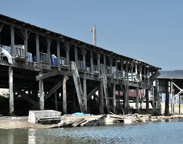
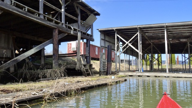
#4 Raymond Riverfront Park. Next to Willapa Paddle Adventures, the Willapa Seaport Museum and the NW Carriage Museum is a hand carry dock with an added easy kayak launch. The Willapa River forks here giving you three major routes some which are shown here. Below is a view of the dock, the nearby lumber mill and swing bridge.

#5 Helen Davis Memorial Park is on the Willapa River at the west end of South Bend. From here it is a 5 mile round trip to Willapa Bay and a 9 mile round trip to Raymond as shown here. Dock repairs to the hand carry kayak dock adjacent to the Elixir Coffee Shop were completed in 2023.

#6 The Bone River Natural Area Preserve No facilities, limited parking and a steep muddy hand launch at lower tides offers a 5 mile round trip that’s historical and protected from development. Launching from nearby Bay Center would make this a 13+ mile round trip as I did here.

#7 Bay Center From the marina’s dredged ramp you can paddle upstream to the Niawiakum River and/or the Palix River delta. Shown below is the ramp and Goose point Oysters at the entrance to the Niawiakum River.

#8 Palix and Canon Rivers Accesses the three forks of the Palix River and the Canon River through the meadows and forests as written about here. Located 1/3 mile south of the US 101 bridge over the Palix River.

#9 Naselle Launching onto the Naselle River at Naselle you can paddle upstream or downstream through pastures and forests before reaching Willapa Bay 12 miles away as I’ve done here.

#10 The 101 bridge over the Naselle River has parking above a path down to the river which can be seen further in these posts: https://southwestwashingtonpaddletrips.wordpress.com/2017/06/19/naselle-river-mouth/

Shown below is the lot and the nearby Ellsworth Slough.

#11 Willapa National Wildlife Refuge Ramp provides access across to Long Island, with campsites north and on its west side. A collection of posts crossing to the island to hike the trails around the old growth cedars can be found here.

The Willapa National Wildlife Refuge Headquarters has moved from here southwest across the bay adjacent to the Dohman Creek launch.

#12 Dohman Creek provides access to Willapa Bay’s southern salt marsh and the Tarlett Slough. This launch opened within the Riekkola Unit late 2018. Turn east off Sandridge Road at 67th Place and drive 2.3 miles to a restroom and parking lot. Below is a picture of the launch and Tarlett Slough as written about here.

#13 Port of Peninsula at Nahcotta: Is located 12 miles north of the intersection of Highway 101 and Sandridge Road at Seaview. From here you can see the the local oyster industry and waterfront homes. Two miles east is the northern end of Long Island, a crossing that is unforgiving to poor planning and may leave you stranded until the tide returns. I’ve written about it here.

Bonus: Posts of Accessible Lakes and Canals on the LB Peninsula

From the north at Surfside and continuing south there is Surfside canal & Seabreeze Lake and Loomis Lake,

Island Lake and Black Lake.

These are collected from my collection of posts that features the Columbia River west of Longview, the Oregon coast from Wheeler north to Ocean Shores Washington.

A guide book is available in several shops, by mail or on Kindle and is available here.

Clatskanie River’s Culvert to the Westport Slough

March 18, 2023

I’ve been wanting to further check this area for a long time. On a map it appears there is a route parallel to the Columbia River from Westport to the mouth of the Clatskanie River, almost. I’ve read feed back from other people who are curious too. There are two gaps labeled on this map.

On the left end is the entrance to Westport Slough where there is an excellent ADA kayak launch at Westport, Oregon. The blue marks the Columbia River, the red marks the Westport Slough and part of the Clatskanie River system inland up to the Quincy Mayger Road bridge. I documented a portage through the gap on the left. The bank entering the slough was steep but I was fortunate that it was a slide down and not a pull up through the brush with my heavy boat. I wrote it up here.

If doable, the second gap to the east offered the possibility of sheltered waters paralleling over seven miles of the Columbia. I found an entry regarding this gap in the excellent 2004 book by Keith G. Hay: The Lewis & Clark Columbia River Water Trail available here.

Regarding passage, Mr. Hay offered a paddle through the gap if the tide was low with the possibility of a portage if a person didn’t want the thrill of a culvert:

Today I planned to launch here and observe at what tides the culvert works. When I arrived, the tide was rising at +6.7′ feet and about to turn. I planned to paddle east around Anunde Island, then north around Point Adams onto a sheltered bit of the Columbia. 3.5 miles into trip I would portage back onto Westport Slough and down the steep bank where I would rejoin the main path of Westport Slough four miles into trip. The loop would total about seven miles. When I returned, the tide would have fallen to a bit over +2 feet to show another extreme of the culvert.

Off I drove to find out.

This must be the place. This sign credits the many who made this culvert possible and encourages research to find out more. A quick search revealed from NOAA Fisheries that they “Removed dirt plug between river and slough, replaced with arch culvert to allow fish access to 8 trubitaries (sic) and water flushing of Westport Slough. Should reduce sediment load in slough.”

Looking west, here is the slough from Westport. My original plan was to loop back here in four hours after heading in the other direction. In the nineteen years since the book was written the banks have grown thick with Himalayan Blackberry.

There was one short path in the area and it went east to the Clatskanie River. It offered no view of the culvert but pulling aside some blackberries elsewhere I was able to photograph it. There was a small current westward as the tide was turning at +6.9 feet (as measured in nearby Wauna).

Being March, the blackberries are bound to further fill in the launch path during the summer.

Off I went to get a water’s view of the culvert. The divider was a deal breaker to me.

A local stopped to chat. He lives nearby on the northeast shore and paddles with his grandkids. He recommended that I return before the tide dropped to three feet. He can see the culvert from his dock but has not been tempted to paddle through because the Westport Slough is shallow at this end. I gave him a copy of the Launch Guide book I publish as he was unfamiliar with some of my favorite trips nearby. We both agreed that nearby Jones Beach on the Columbia River can be rough and exposed. Then he told me to watch for a waterway a farmer dug in the 1930s. It would take me through the fields and rejoin the Clatskanie River upstream. After he verified I knew what time to be back to avoid becoming stuck in the mud, I paddled off to find this uncharted route.

This looks like a narrow entrance to something worth exploring.

I had found the passage. It is more shallow than the Clatskanie but plenty wide.

Later research gave it a name: The Kinnunen Gut. That called for a directory which explained that “a ‘gut’ is a relatively small coastal waterway connecting larger bodies of water or waterways.” It is shown as a dead end on my large NOAA chart #18523 and on GoogleMaps where it is labeled the Kinnunen Cut. Calling it a gut will raise an eyebrow.

It was not a dead end as I later paddled into the Clatskanie River on a falling +5.8 foot tide.

It was a mile and a quarter paddle downstream to the Columbia River overlapping a trip I have previously written about here. On that trip, I was trying to figure out a large mysterious concrete structure that looks so out of place on a satellite view. The local land owner I had met didn’t know about it, and it still remains a mystery.

On their return trip the Lewis and Clark Expedition camped further down down the Columbia River near Aldrich Point on March 24, 1806. On March 25, they camped here at Point Adams. What is also here is this interesting fishing industry relic.

Gear is still stored on the precarious looking upper story of this building above the many old docks.

I spotted an otter or a nutria ahead and paddled to where I though it might emerge.

The critter didn’t appear as maybe it was fishing.

Owners of the vehicles parked nearby were out fishing too.

And there were those who have always fished here.

A bulky camera that had been slowing me down all day got some use.

I circled around to admire this boatbuilder’s style, particularly the compound curves on the bow.

Soon I headed back up the Clatskanie and into the loop with the culvert.

Here is the culvert again at a falling +3.3 foot tide. Water was flowing towards me vigorously turning my bow away, not that I wanted to enter anyway. The entrance path is to the right, now with a soft mud beach.

Here’s a minute plus of video demonstrating the decision not to paddle through.

The book was right. From the blackberry launch it is only a mile to the Columbia, which is closer than the 2.75 mile paddle from the Beaver Boat Ramp in Clatskanie.

A Red-winged Blackbird entertained me as I loaded for home.

Did I find an island? According to the Inventory of the Julia Buttler Hansen Refuge, Appendix F, under Islands: …the “Kinnunen Cut is not being considered because it is a human-made cut, which was previously part of the Oregon Mainland.” Apparently digging a trench does not create a new island. Here is a map from Anyplace America that provides the best satellite view of today’s trip. The tracking information from my phone’s MapMy Tracks app.

I recently read an excellent book of kayaking (and towing his kayak with his bicycle) across the the United States titled The Misadventures of a Cross-America Kayaker released late in 2022. He described headwinds, fog, rough water and silent freighters sneaking up from behind as he paddled upriver on the Oregon side of Puget Island and around the nearby Wallace Island. He could have entered the Westport Slough and exited near the upstream end of Wallace as he was also using Mr. Hay’s book as a guide. I wrote to him regarding his thoughts of the Westport Slough and he replied…

“…In retrospect I wish I had taken it. I suspect I did not for the same reason you cited; uncertainty about the culvert (and running aground in the slough at low water). The Columbia River Water Trail Guide was a little light on the details and didn’t provide a photo. Oh, well, there is always next time.”

I have more trips planned in the area too.

As I left, I stopped at the first bend to take a parting picture westward of the Westport Slough. The +2.6 tide would leave a paddler feeling poorly in this gut.

Here are the numbers that don’t quite agree with each other from MapMy Walk and Garmin.

Let’s keep: 6 miles traveled in 2 hours 20 minutes (according to the Garmin that measured stopped time) with a maximum speed of 5.3 mph averaging 2.4 mph.